Lesson summary
Students use the fire triangles to understand the elements that influence how fires burn and behave. They conduct a risk assessment of their local area based on these elements, predicting where they might be most vulnerable to a bushfire event.
Learning intentions:
Students will...
- understand the elements that influence how fires burn and behave.
Success criteria:
Students can...
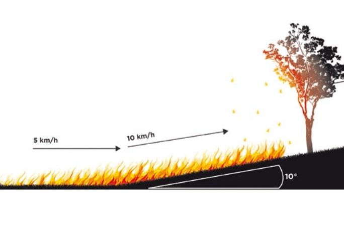
- explain the three elements of a fire and the three things in the environment that impact how it behaves
- conduct a risk assessment of their local area to predict where might be most vulnerable to a bushfire event.
Lesson guides and printables

Lesson details
Curriculum mapping
Australian Curriculum content descriptions:
Year 5 Geography:
- The environmental and human influences on the location and characteristics of a place and the management of spaces within them (ACHASSK113).
Relevant parts of Year 5 Geography achievement standards: Students identify and describe the interconnections between people and the human and environmental characteristics of places, and between components of environments.
Syllabus outcomes: GE3-2, GE3-3.
General capabilities: Critical and Creative Thinking.
Cross-curriculum priority: Sustainability.
Level of teacher scaffolding: Medium – facilitate student discussion and support with independent investigations.
Resources required
- Art supplies – coloured pencils and textas (optional)
- Device capable of presenting a Powerpoint to the class
- Individual devices capable of accessing the internet
- Lined paper or workbook
- Powerpoint
- White paper (optional)
Skills
This lesson is designed to build students’ competencies in the following skills:
- Community engagement
- Critical thinking
Additional info
We encourage you to undertake the free PD Course How to teach a unit on fire and flood resilience for tips on how to best deliver this lesson.
If you’re concerned about the challenging nature of these topics, consider the free PD Course How to approach trauma in the classroom for information on how best to support your students.
This lesson was made in partnership with
Minderoo Foundation (www.minderoo.org).
Welcome back!
Don't have an account yet?
Log in with:
By signing up to Cool.org you consent and agree to Cool's privacy policy to
store, manage and process your personal information. To read more, please see
our privacy policy here(Opens in new tab).
Create your free Cool.org account.
Many of our resources are free, with an option to upgrade to Cool+ for premium content.
Already have an account?
Sign up with:
By signing up to Cool.org you consent and agree to Cool's privacy policy to
store, manage and process your personal information. To read more, please see
our privacy policy here(Opens in new tab).